|
|
Runyan Lake Inc.
The lake association for the entire community
of Runyan Lake
|
|
|
|
|
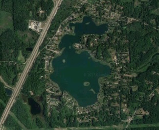
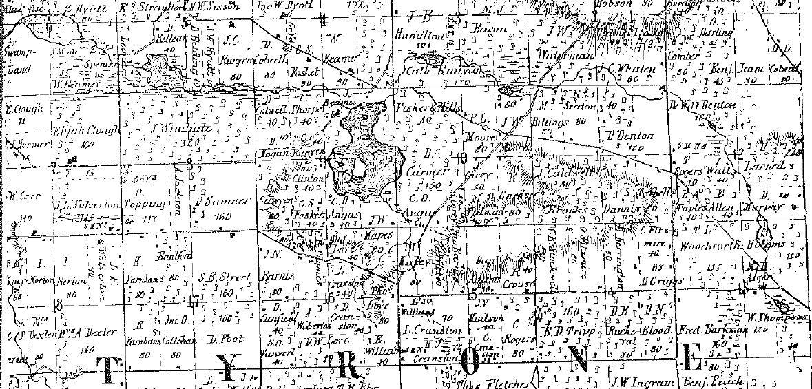
History of Runyan LakeThe History of Runyan Lake, Livingston County, Fenton, Michigan The area in which we are located was a historical marl mining area. Marl Lake is named because it was a site for mining marl, a type of clay, from the 1890s to 1930s. Aetna Portland Cement Co. and the Egyptian Portland Cement Co., both of Detroit, purchased property around Fenton and in 1900 began erecting factories. Aetna built its plant on the southwest shore of Lake Ponemah, then known as Mud Lake. The Egyptian Co. built its plant on the north shore of Silver Lake. They began manufacturing cement in 1902 and 1903 respectively. Egyptian closed its plant in 1920. Aetna closed theirs in 1936. While there remains some mystery about the origin of Runyan Lake, maps dating back to the 1800’s clearly show Runyan Lake has existed for quite some time. The map below is from 1859, and while it lacks some measurement details, Runyan Lake, Hoisington Lake, and Bennet Lake are all present.
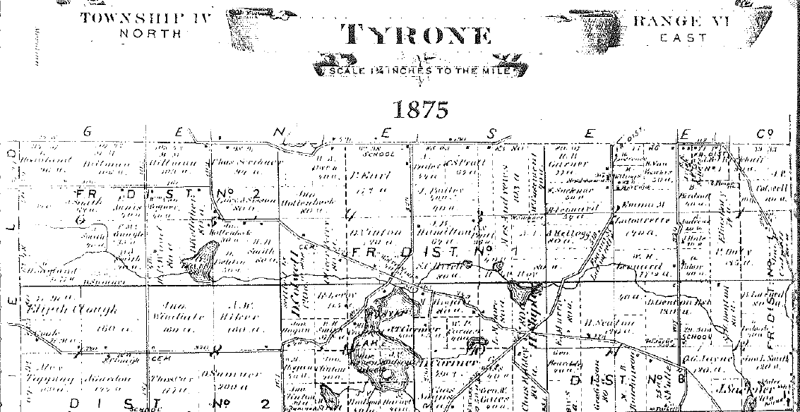
The map below, dated 1875, offers more dimensional accuracy and detail, showing not only Runyan Lake but also the large pond southwest of the lake. The island is clearly documented even at this time.
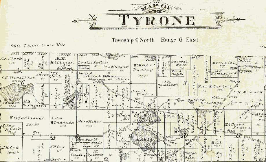
Map detail continued to improve as shown on the below 1895 version.
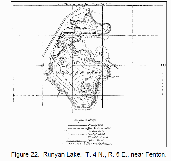
Many of us have questioned whether Runyan Lake is a natural lake, or whether it was created during the local area cement boom in the early 1900’s. As we have shown above, the lake clearly existed prior to the marl and clay mining activities came to our area. Many may even recall the historic cement factory along the railroad tracks between Silver Lake and Lake Ponehma (known historically as Mud Lake) before its demolition sometime around 2005. Historical records recently found bring light to the history of our area. The following is found in the book Lower Peninsula, 1900-1903, Volume 8, Parts 1-3:Egyptian Portland Cement Co. Organized June 30, 1900. Capital, $1,050,000, in $10 shares. Also bonds, $350,000. The officers are, George A. Foster, president; J. Fletcher Williams, vice president and general manager; C. B. Shotwell, secretary, and E. D. Kennedy, treasurer. The factories are at Fenton and Holly. Robert W. Hunt & Co., are engineers and W. H. Hess, chemist. We reprint many of the careful surveys which were made of the company's lime lakes. One (Plate XXI) is of Silver Lake, the Fenton property, and another, (Fig. 21) is Raffelee Lake, the Holly property of the same company. In Plate XXI the bluffs which mark the original margin of the lake are shown as in Fig. 13, and if we compare the outline of the lake with that shown in the county atlases from the original land office surveys, we find it entirely different. Apparently a good deal of this is due to the filling up of the lake by the deposits of boglime, isolating "daughter lakes," as Davis has described them, from Littlefield Lake. It is possible, however, that a change of lake level may also have been an important factor. Finally, but not least important, the surveyors in meandering these marsh bordered lakes, which are often full of rushes, find it very difficult to determine where marsh ends and lake begins. We also reproduce reductions of careful surveys of Runyan Lake, Sections 9 and 10, T. 4 N., R. 6 E. (Fig. 22), and of Mud Lake, just north of Silver (Fig. 23). Also of lakes on sections 27, 28 and 30 and 29 of Holly township (Figs. 24 and 25). There is peat in connection with these deposits "partially overlying and directly contiguous, which it has been proposed to use as fuel, though it is not at present seriously planned. The coal and very probably the shale will come from the neighborhood of Corunna, The Grand Trunk and the Pere Marquette system cross at Holly. A resurvey after some years, of such of these properties as may not have been seriously touched, will give important light on the growth of the deposits. Extracts from the prospectus, Robert W. Hunt & Co.'s report, are as follows: Report dated Jan. 30, 1900. We beg to submit the following report in full on the survey and investigation of the marl lands situated near the cities of Fenton and Holly, Michigan. The marl land surveyed and sampled consisted of four separate deposits. The first and largest, is in the southeast corner of Genesee County, two miles west of the town of Fenton, and extends south into the northern part of Livingston county (Plate XXI). The second is in Oakland County, two miles east of Fenton, and about midway between Fenton and Holly.
The third deposit is in and north of the town of Holly. The fourth deposit is about two miles southeast of Holly on Raffelee Lake (Fig. 21). The first tract consists of Runyan Lake (Fig. 22), Marl Lake, Upper and Lower Silver Lake, a part of Mud Lake (Fig. 23), Squaw Lake, and the low swamp land contiguous to these lakes, together with a strip of land in the town of Fenton. As a rule the hills surrounding these lakes are high and steep, and the slope of the marl deposit is quite abrupt, which latter is also true of the lake bottoms. Many bars of marl, covered with only a few inches of water, extend into the lakes, but just off these bars the water is deep. The second tract (Fig. 24) consists of marsh land around Warren Lake and several small ponds near by, Dickson Lake and the two Mineral Lakes. The hills around these are also high and steep and the shores are abrupt. The third tract (Fig. 25) is in and around Bevin Lake and Bush Lake. There are no hills around these lakes, and the marl deposit is shelving, and the shores are not abrupt. A large part of Bush Lake is only a few feet deep. There is no tamarack or underbrush. The fourth tract is along the south edge and west end of Raffelee Lake, including the swamp lands just west and northwest of Raffelee. Part of this swamp land is heavily timbered, and the average stripping is about two feet. The first tract is cut by three highways and the Detroit, Grand Haven & Milwaukee railroad track, together with the public road which lies between Silver and Mud Lakes. Another road is just south of Silver Lake, and still another south of Marl Lake. There are no public highways crossing the second tract, but the main highway between Fenton and Holly runs very close to it. Between Bevin and Bush Lakes are the tracks of the Pere Marquette railroad, a public highway and some meadow land. The Detroit, Grand Haven & Milwaukee railway runs alongside of Raffelee Lake. There are no highways crossing this tract, but it will probably be easy to secure one on the section line. Figure 25. Bush Lake, Sec. 27, T. 5 N., R. 7 E, and adjacent marl beds nea Holly. The maps which we send you will show the location of these different tracts. There are eight detail maps, which show all lands surveyed and sampled, except where the results were not good enough to justify mapping the properties out. These maps show location of property, name of original owner, and location of test holes from which marl samples were taken. The numbering of these test holes is the same as the sample numbers in the complete analysis. In determining the extent of the deposits, about four hundred additional test holes were sunk, from which no samples were taken. The following statement shows total acreage: Considering the results obtained from the chemical analysis of the marl, lots or deposits of marl have been located wherein the marl, as shown by the analysis, is of such composition as is required to make good cement. The total amount of marl in the foregoing lots, upon which we report favorably, is 14,350,720 cubic yards, which is enough to manufacture about 28,700,000 barrels of cement. The following tables show the maximum, minimum, and average determination of the samples from the accepted lots, together with the average depth of marl, quantity of stripping, and quantity of marl in each lot. The best locations for cement plants are upon the Grand Trunk railway, between Silver and Mud Lakes at Fenton, and upon the same road at Raffelee Lake, just east of Holly. At the latter point the Pere Marquette system would doubtless be glad to build a switch into the plant, giving it the benefit of junction point rates, which could probably be extended to include the Fenton plant as well. From the chemical analysis of marl, its desirability for the manufacture of cement is determined. The analysis also gives data for determining the amount of clay that should be mixed in order to give good results. A large percentage of silica is not desirable, but four to five per cent is not prohibitive, providing it does not vary to too great an extent. The amount of iron and alumina oxide that is detrimental depends upon the analysis of clay with which the marl is to be mixed. The magnesium carbonate should not be over four to five per cent, which, of course, will be reduced in the finished cement between two and three per cent. If the amounts of silica, iron and alumina, and magnesia in a body of marl are small, a comparatively large variation in the calcium carbonate can be allowed, because its percentage will vary almost directly as the amount of organic matter. We would respectfully recommend that all material possible be conveyed by mechanical means, and that the labor account be reduced as low as possible. (Signed) ROBT. W. HUNT & CO. Lansing, October 1, 1900. Egyptian Portland Cement Company, Detroit, Michigan. Gentlemen—I beg leave to make the following report of tests of cement made from clay and marl received from you from Fenton, Michigan: FINENESS. SETTING TIME OF NEAT CEMENT. Very respectfully, (Signed) R. E. DOOLITTLE, Chemist. Lansing, Michigan, Oct. 1, 1900. Egyptian Portland Cement Company, Detroit, Michigan. Gentlemen—I have been investigating the peat question, and submit for your information the following table: In examining this table, note the column designated "Calorific Intensity," and notice you can get as high heat with peat as you can with bituminous coal, lacking 150 degrees Centigrade, and the conclusion is therefore warranted that you can burn Portland cement with dried peat as rotary fuel. It would not cost over twenty cents per ton to prepare peat for rotary work, using waste heat as a drier. The grinding would be very easy. Yours truly, (Signed) W. H. HESS, Chemist. Twentieth Century Portland Cement Company. Organized March 2, 1901. Capital, $750,000.00. Office at Fenton and plant about four miles from the village, and stock said to be mainly held there. It is said that marl options are held on Runyan Lake, mainly in Sec. 9 (see Fig. 23), and elsewhere, amounting to 526 acres, and 9,500,000 cubic yards. This is not a very large supply and so far as I know, this and the following companies and locations referred to are not very near production.
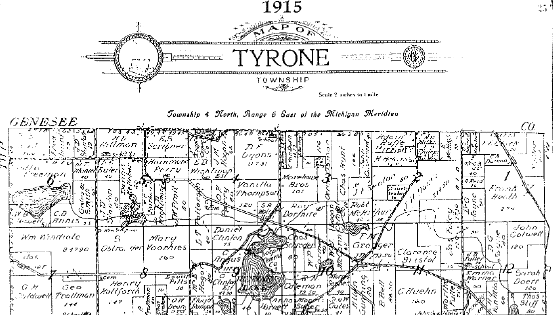
So what is our history? In 1900, Runyan Lake was identified as a viable marl deposit, but had not yet been mined. Note the description from above of Runyan Lake at this time: "The first tract consists of Runyan Lake (Fig. 22), Marl Lake, Upper and Lower Silver Lake, a part of Mud Lake (Fig. 23), Squaw Lake, and the low swamp land contiguous to these lakes, together with a strip of land in the town of Fenton. As a rule the hills surrounding these lakes are high and steep, and the slope of the marl deposit is quite abrupt, which latter is also true of the lake bottoms. Many bars of marl, covered with only a few inches of water, extend into the lakes, but just off these bars the water is deep." This describes the characteristics of Runyan Lake today, and correlates with the Runyan Lake depth analysis shown in Figure 22 from 1900 above. A map of Runyan Lake from 1915 shows the lake size unaltered from the 1895 map. Note the land ownership in the current Runyan Lake Point area – Logan Cement Company.
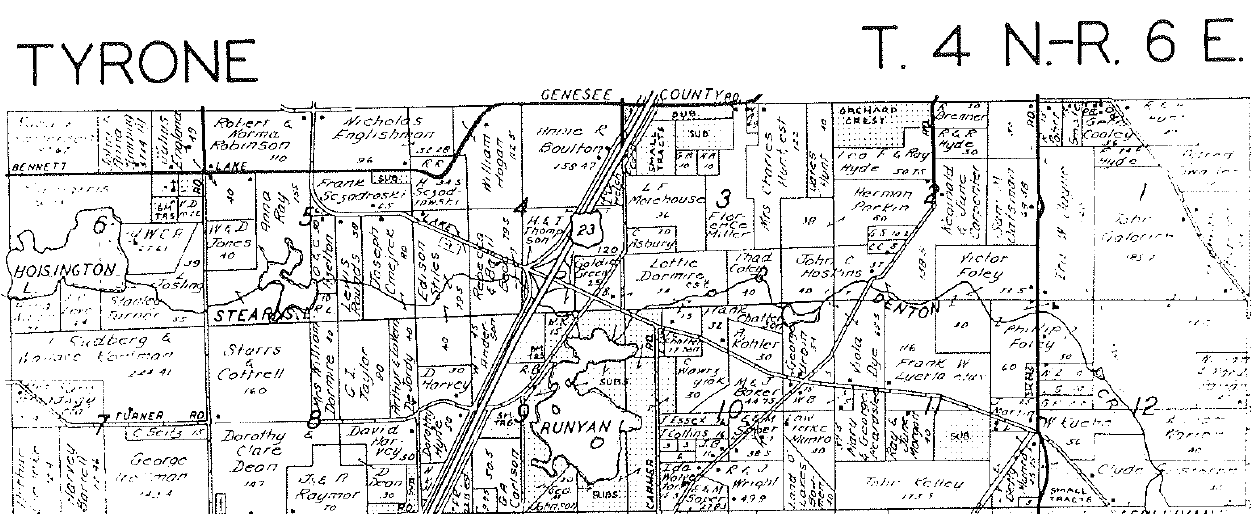
This entry was also posted, noting available resources after 1901 not yet mined. Twentieth Century Portland Cement Company. Organized March 2, 1901. Capital, $750,000.00. Office at Fenton and plant about four miles from the village, and stock said to be mainly held there. It is said that marl options are held on Runyan Lake, mainly in Sec. 9. Fast forward to 1965, below, and Runyan Lake remains as it appeared in the 1900 time frame.
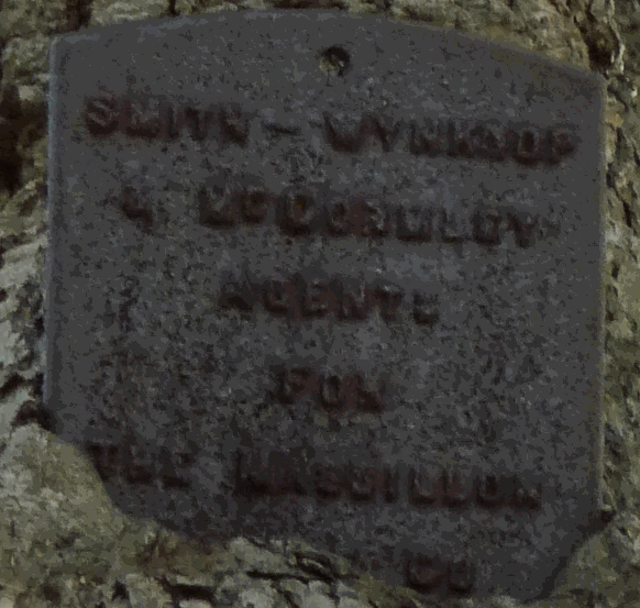
By now the subdivisions of Runyan Lake Heights (1928 and 1929) and Runyan Lake Point (1932) have been platted, and Runyan Lake Cove (1960) has been connected to Runyan Lake. But the physical size of the lake is unaltered, and the descriptions of extended marl deposits in shallow water giving way to a deep lake bottom are consistent with our present lake condition. The island is included in the 1859 map so it was not created by a mining operation. There is no historical evidence of the railroad expansion to Runyan Lake mentioned in the prospectus report. Conclusion: Based on all the historical evidence referenced above, Runyan Lake is a natural lake, created as a result of the hills and valleys in the immediate area formed by glaciers, and while containing a respectable marl deposit, was never mined as proposed in 1900 due to limited access and the small amount of marl available. The proposed railroad spur to connect Runyan Lake to the then existing railroad to transport extracted marl was never constructed. The lake today is largely as it was in 1859, the earliest survey record found of our lake. Acknowledgements: We would like to thank Terri Medor, Tyrone Township Deputy Clerk, and Mark Meisel, a Runyan Lake resident, for their research and contributions to result in the location of historical records for Runyan Lake. This effort all started as a result of curiosity about a plaque found imbedded into a tree on the shore of Runyan Lake (below). As it turns out, THE MASSILLON BRIDGE CO was a builder of concrete bridges in Michigan and Ohio in the 1800s, and appeared to be securing marl reserves for the concrete they needed to build their bridges. Property around Runyan Lake was claimed for that purpose.
"SMITH-WYNKOOP & McDORMLEY AGENTS FOR THE MASSILLON BRIDGE CO" (Note – Plaque has a typo! McDormley should be McGormley) References: Historicmapworks.com Lower Peninsula, 1900-1903, Volume 8, Parts 1-3 By Michigan. Geological Survey MICHIGAN GEOLOGICAL AND BIOLOGICAL SURVEY. Publication 8 Geological Series 6 DIRECTORY OF AMERICAN CEMENT INDUSTRIES FOURTH EDITION. REVISED
|
|
Runyan Lake Inc. PO Box 105 Fenton, MI 48430-0105, USA
Reproduction in whole or in part in any form or medium without express written permission from Runyan Lake Inc. is prohibited. Please view our: | Privacy Policy | Terms of Use | Site Map |
|